
Saturday June 22
Arrive in Anchorage 7pm (10pm home time) Springhill Suites.
Get rental car, find hotel, crash
This was pretty much as expected. We arrived close to on time, and although it was as bright as noon outside, we all felt pretty exhausted. We swung by Moose's Tooth, as it was a recommended place to eat, but the line was long and we were too pooped to pop. So then we swung by a nearby sushi restaurant, but it was also a long wait. Dylan was pretty congested from the flight, and had an awful headache. At this point, we just wanted food and bed, so we drove through Wendy's and then ate in our hotel. The most expensive Wendy's meal we have ever had, but it was what we needed. We knew we had a long day the next morning, so we pulled the blackout curtains and went to bed.
Sunday June 23 Drive time: 6-7 hours Overnight: Riley Campground
Plan: Hit Walmart for Camping supplies. Depart Anchorage: 8:00am Arrive Talkeetna: 11:00am (2 hour google drive plus added time for construction).
Talkeetna Options (if no traffic delays)
Visit Alaska Birch Syrup and Wild Harvest for tour starting on the hour
Take Talkeetna History Quest 45-60 minutes here
Check in with Talkeetna Air Taxi by 12:45 for 1:30pm Southside Explorer with Glacier Landing Tour
Depart Talkeetna: 3:30pm Arrive: Denali NP: 6:30pm (2 hr 40min google drive).
Arrive Denali one hour before visitor center closes. Pick up transit pass, sign up for Disco hike. Eat dinner and set up camp.
Having gone to bed before 9pm local time, we were up pretty early the next morning. Dave and I hit Wal-Mart to buy some supplies, and then we were on our way. I had heard very mixed reports on how long to expect the road trip to Talkeetna to take, and since the tickets were pretty expensive, I didn't want to miss it. So we got a pretty early start, and didn't make any stops along the way - except to pick up a different cooler from the Walmart in Wasilla, because the Anchorage Wal-mart had a pretty slim selection. Wasilla's selection wasn't much better, so we wound up purchasing a styrofoam cooler. If there is one thing we would have done differently, it would have been to pick a better cooler. As the days went on, our poor styrofoam cooler got more and more beat up. But it did the job.
Alaska Birch Syrup and Wild Harvest


We *loved* this tour. Our family loves to geek out on all the details, and this was the perfect tour for us. They started outside to show us how they harvested the birch.
We then went inside, where they showed the process of making birch syrup.
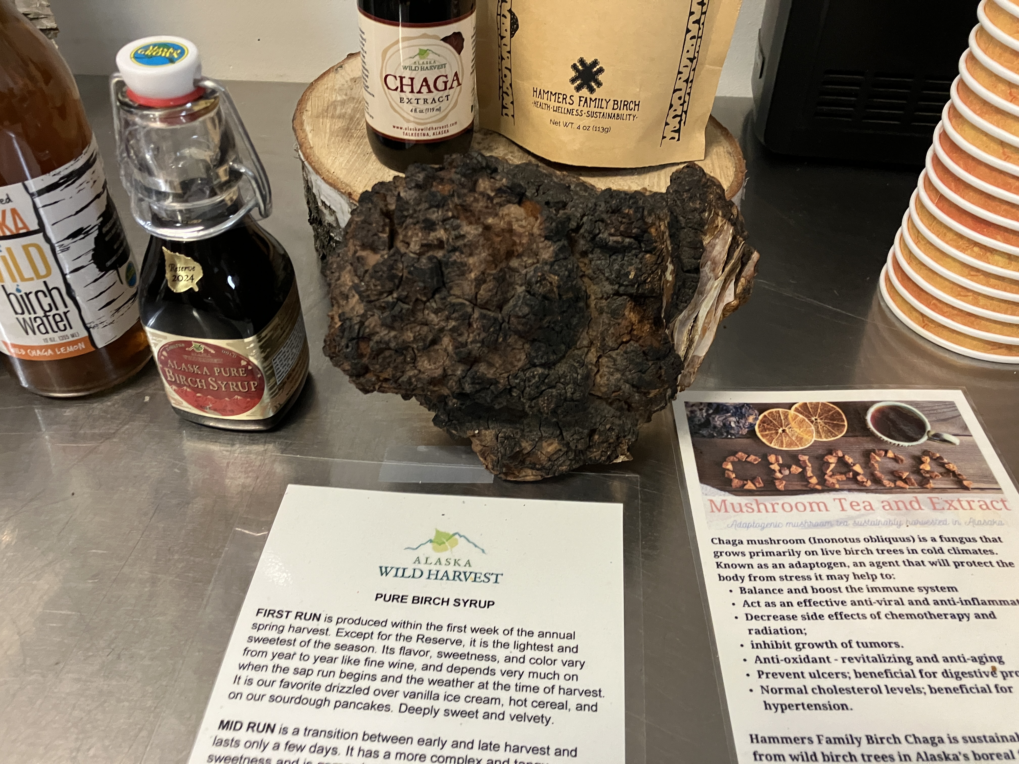 |
| A example of chaga, which has a parasitic relationship with birch trees |
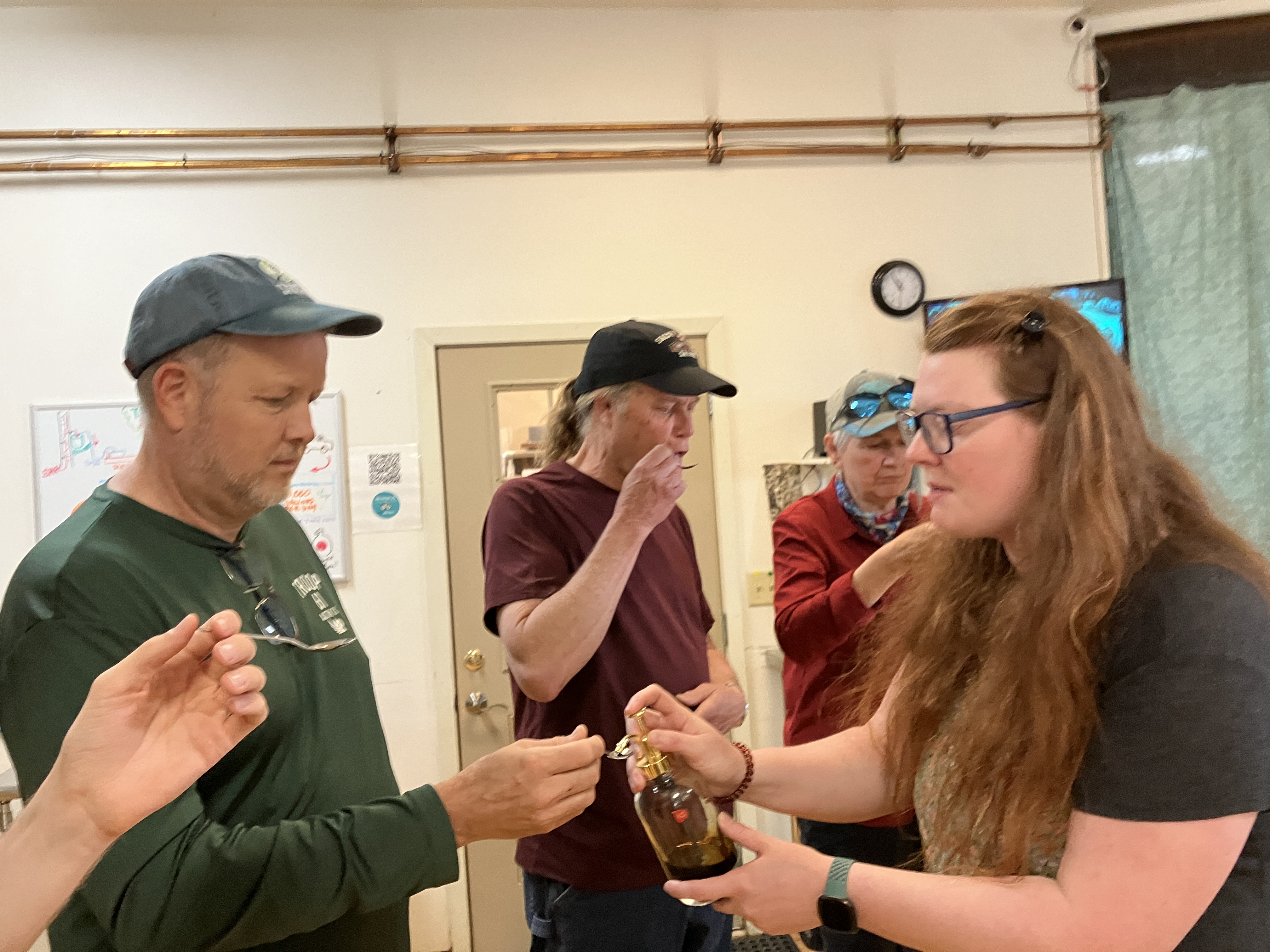 |
And probably the highlight, they then let us taste a variety of different process of birch syrups. Based on when they pulled the syrup from the tree, resulted in a different flavor. |
We then visited their gift store to purchase some treats. A really cool start to a really cool trip.
After this we went into Talkeetna to grab some lunch before our flight was due to take off.
The scenery was so lush and green, that we had to make a quick stop along the way to admire it!
 |
| Just a standard roadside stop, but aaah the greens, and flowers, and fresh smell. |


We were hungry, and time was a little tight to make our flight. We were also having some trouble locking our car, which we eventually figured out. So we grabbed a quick lunch from a BBQ food truck and then headed to our flightseeing tour.
Talkeetna Air Taxi
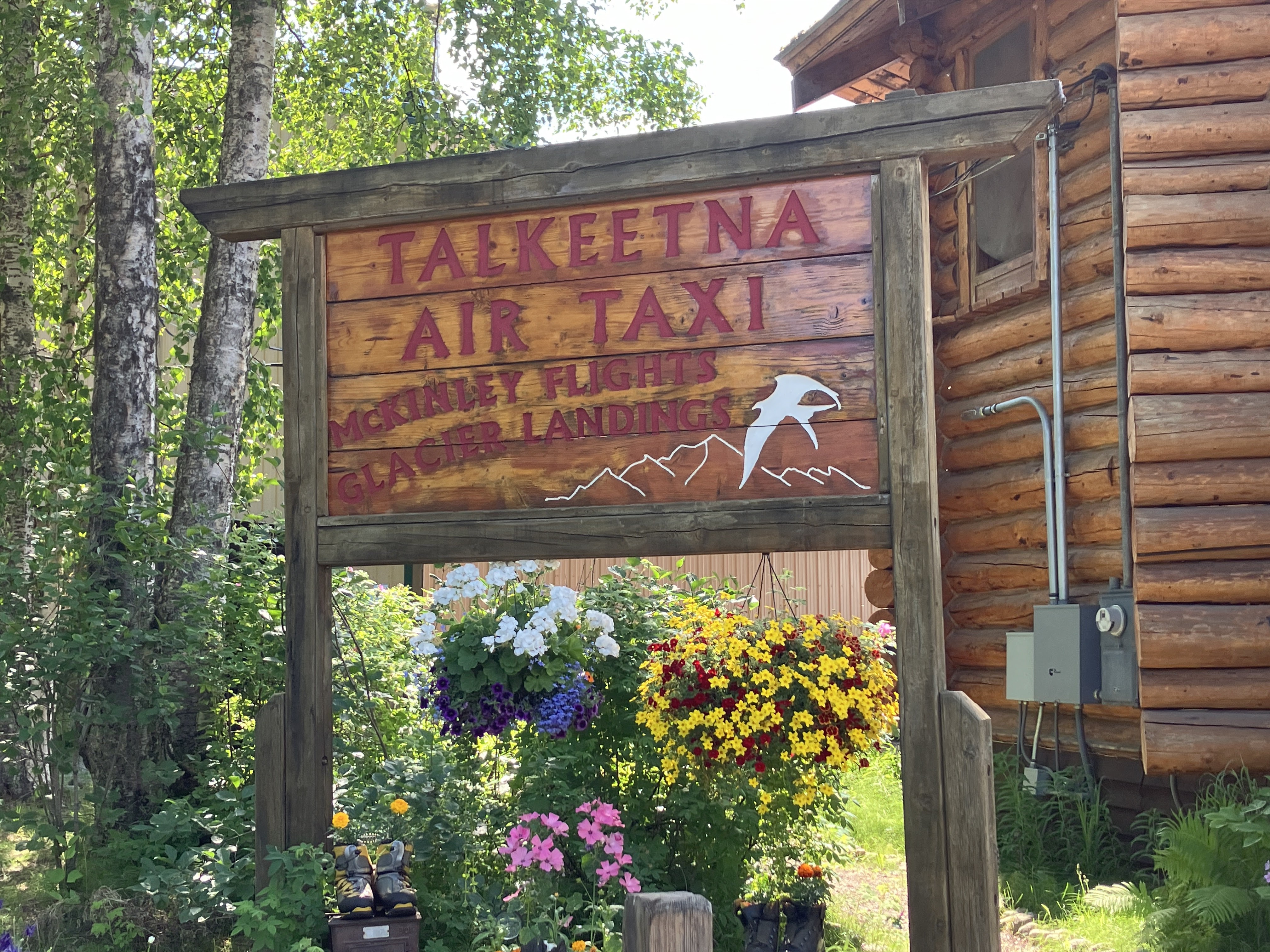
This was expensive. Very expensive (especially since there were 4 of us). But seriously, everything is expensive in Alaska. And I have heard many people say this was the highlight of their trip. In planning the trip, one of the decisions I made was to spend the majority of our budget on experiences, and budget where we stayed. We camped for many nights, but didn't skip any of the outings.
This was our first outing, and we opted to select not just the Southside Explorer flight, but also the glacier landing. As always, I was incredibly nervous it would be disappointing.
Yeah. It wasn't.
 |
| Alaska is the land of glaciers, with (supposedly) more glaciers than the rest of the planet put together. We saw at least one glacier almost every day we were there, and usually more than |
 |
| Ruth glacier (coming in from the right) joining with a tributary glacier from the left. You can also directly see how medial moraines form! |
This tour was incredible, and a really great way to see Denali National Park. Denali is a **huge** park, and there is only one road through it, so the flightseeing tour was a great way to see the whole park. Liam was our guide, and he provided a lot of information about what we were seeing. It was a great introduction to the area and the park. On this trip, we got to see a lot of glaciers. And every view was different. We were kind of glad that our very first viewing was the sky-high view. It really brought home the enormity of the land.
And then we landed. We were fortunate enough to be the only ones at this sight, until sometime later another plane landed.

To stand, quietly surrounded by this beauty, is something that words just cannot express.

The Glacier landing was truly special and we would also highly recommend adding it, if possible. |
| Team Read on the glacier, with Denali in the background, peeking above the darker, shorter mountains. |
We then headed home. On the way out, Kyle was lucky enough to score the passenger front seat, and on the way back, he made sure Dave got to try it.

But no matter where you were on the plane, it was incredible. And the commentary about the land, really prepared us for the days ahead.
 |
| More glacial meltwater. You can see that the river in the background is glacial water because it looks kind of gray. This is due to all the silt and minerals that the water picks up from the glaciers. All across SW Alaska, you can tell spring water from glacier water at a glance: clear water comes from a spring, gray or turquoise opaque water comes from a glacier |
 |
| One important thing to remember about glaciers is that (a) 70% of all freshwater on earth is presently stored in glaciers, and (b) when glaciers melt, that water has to go somewhere. The rivers shown in this photo are all meltwater -- they will dry up in the winter when the glaciers refreeze. But in the summer, these rivers are carrying ridiculous quantities of water to the ocean. If you're wondering why scientists are talking about sea level rise in the era of "climate change," wonder no more. |
We had a quick meal at Denali Brewing Company. One of our better meals while in Alaska, then headed to Denali National Park
As with the first night, so with the rest. The late sun really allowed us to extend our day.
We arrived around 7pm at Denali, checked in, found our tent spot, and set up our tents. This was the moment of truth, would our camping gear do the trick??? Except for a mix-up with our screened in tent (I packed the wrong one?!?) the nights we spent in our tent were comfortable and, for the most part, easy.
While packing for the trip, I catalogued all of our camping gear, and found we had at least 3 nights of backpacking meals. These meals came in handy for the many late nights, where we would get in late, put up our tents, and then quickly heat up some water to eat our backpack meal. But there were other nights where we would throw together a quick meal of burgers, or even just feast on some crackers, cheese and grapes. So, this evening, we made ourselves a quick dinner and then crashed in our tents.
At 5+ hours, we knew this would be our longest day of driving, but with the break in the middle at Talkeetna, it made it totally do-able. We were also fortunate to not have any construction or heavy traffic on the way.
It was odd, having a 3am bathroom run, with the sun out. But, for the most part, each day we did so much, we pretty much put on our eye masks and fell promptly to sleep. Kyle and I both tried melatonin, and that seemed to help as well.
Monday, June 24 Drive Time: 0 Overnight: Riley Campground
Morning Options
Visit Denali Visitor Center: Open 8am - 6pm
Sled Dog Demonstration: 9:20am, 1:20pm, 3:20pm. 30 minute presentation, free bus leaves from Denali Visitor Center
Horseshoe Lake Trail: Horseshoe Lake Trail: 2 miles, 2 hours Access via Mile 1 of Denali park Road, or across Park Road from third upper parking lot
10am and 2pm: 2 hour ranger led hikes from visitor center
Afternoon: 2pm East Fork Transit Bus tour 4.5 hours
When designing my itinerary, I often gave "options", knowing that the guys might want to sleep in, while Dave and I would be ready to go. So this morning, the guys slept in. I woke up first, and took a hike around the campground, which was incredibly beautiful. Then Dave woke and we hiked it together. Then Dylan and Kyle woke and we hiked it again. Each time was amazing!
As noted above, I had lots of options for things to do our first morning, and we didn't do any of them. And it was great! If we had had a few more days, I would have loved to do a ranger-led hike or spend more time at the Visitor center, but given our schedule, I was pretty happy with how we spent our time!
 |
| A gorgeous view just a short hike from our campsite |


The Red Squirrel is common in Denali. They make a weird machine-gun chirping noise that sounds like a bird. It threw me off for days. They're super cute, however, and utterly fearless.
 |
| All over SW Alaska, we saw this lovely flower called Blue Bell. The bells are usually blue but not always -- check out this one with blue and violet bells! |
 |
| One of the oddities of birding in Alaska is that many of the birds up there are birds we see in Austin over the winter or during migration. The White-crowned Sparrow above is one of those species. One huge difference, however, is that summer in Alaska is breeding season for these birds, so they are in breeding plumage and singing breeding songs! Thus, they look, sound, and behave differently than they do when we see them in Austin.7 This picture shows the bird with a mouthful of caterpillars. This a good sign that this adult is feeding young -- otherwise he/she would have swallowed the meal right away! |
That afternoon, I had reserved the 2pm park shuttle bus as far as it would go into the park. We didn't actually see much on the bus. It was a cold and wet afternoon, one of our few "bad" weather days. But the bus driver provided a lot of information that made the trip well worth the time.
I spent a lot of time deciding which tour to take. The East Fork Transit Bus tour was highly recommended over the more expensive narrated tour busses. And based on our experience, I would agree. Our bus driver narrated the entire time of the trip. And all the busses stopped at the same spot. And saw the same wildlife.
 |
We arrived back at camp around 7 pm, crawled into bed, and slept the light night away :)
Tuesday, June 25 Drive Time: 2 hrs Overnight: K'esugi Ken Cabin
Morning Options and early afternoon:
Discovery Tour, if available.
East Fork Transit, if Disco tour previous day
Sled Dog Demonstrations (if didn't make previous day): 9:20am, 1:20pm,
Savage Creek Hike: Either take free shuttle or drive 1.7 miles, 1 hour hike
Mount Healy Overlook: 6 miles, 4 hour hike. Accessible from Visitors Center. This would be the only thing we’d really do this day.
Northern Epics Tour 3 hour guided tour. $100 per person
Late Afternoon: Depart Denali 4pm: Arrive K'esurgi Ken Campground: 6pmBreak camp in late afternoon and head south. Check into cabin then eat dinner at McKinley View Lodge, open until 8pm.Possible evening hike at Moose Flats Interpretive Trail .6 mile easy trail
Lots of options this morning. Dave and I chose to go on the Savage Creek Hike, and the guys slept in. I think we were all happy with our choices!
This hike was gorgeous. A stream running through rolling green mountain dotted with wild flowers and baby ptarmigan running around.
 |
| Looking south from the bridge over the Savage River gives some gorgeous views of the Denali landscape.… |


 |
This was an Arctic Ground Squirrel. These guys were super charismatic and unafraid. I took this picture from ~15 feet away, but afterward he let me close in to as little as 3 feet before he retreated into the bushes. |

The views of Denali on the way back were breathtaking.

Visitor Center and Dog Sled Demonstration
We then collected the boys, and visited the the Visitor Center. I honestly wish we had had more time to really enjoy the Visitor Center.
For this whole trip, every place we spent, we decided we needed at least one more day, or maybe a month...
After the visitor center, we watched the 1:20 dog sled demonstration. We got there a little early, which gave us some time to look around, meet the dogs and check out the displays about sled dogs.

Kyle was in his element.

Two or three times a day, they run the dogsled demo at the kennel. It was short, but pretty cool, and we learned a lot about sleds and dogs.

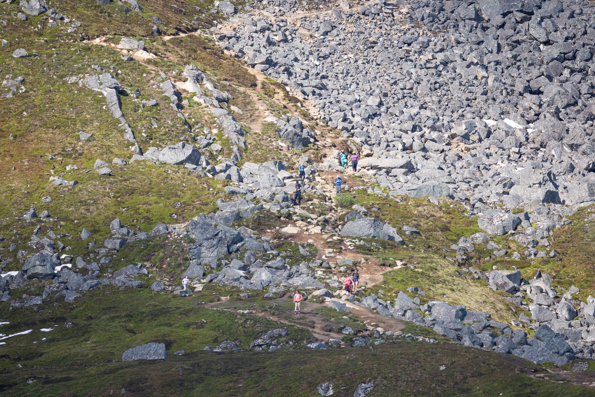
Horseshoe Lake Trail
To limit the amount of driving the next day, based on recommendation from the internet, we opted to not spend our evening in Denali National park, but instead head south to spend the night at Denali State Park.
But we had time for one more adventure before heading out, so we opted to do the Horseshoe Lake Trail, a short two-mile hike that takes between 1 and 2 hours. The trail was downhill to start, then flat around the lake, and then a bit of a haul back up hill.
 |
| We spent three nights / 2+ days in Denali. On our last day, we did a small hike to Horseshoe Lake, which is maybe half a mile from the park entrance. It's a weird little lake, dammed by beavers and inhabited by all sorts of critters. The favorite critter by far was this moose, which was happily grazing on underwater plants and didn't care about this steady stream of people taking pictures of her. |
As we were hiking down to the lake, hikers returning kept promising views of a moose. And sure enough, there was a moose, who seemed very content to ignore us. We spent around 10 minutes just watching him munch his grass. It was pretty incredible.
 |
| Horseshoe lake is small, but it packs a great visual punch. |
After getting to the bottom, seeing the moose, and travelling around the lake, it popped us out on the Nenana River. We sat for a bit, just enjoying the scenery. There are moments of peace that are just hard to explain.

Around 4pm, we left the park and drove a little under 2 hours south, to K'esugi Ken Campground in Denali State Park.
As I mentioned above, we opted to do some pretty expensive excursions, but opted for inexpensive housing. It suited our needs. In K'esugi Ken, they had inexpensive "dry" cabins. I opted for these, thinking if we had experienced a large amount of rain, we may appreciate the opportunity to be under a roof, and dry out our gear. But our weather had been perfect.

 |
| But dang, was this cabin weird. It was obviously originally intended to be a plumbed cabin, but for some reason, they didn't. SO, imagine a nice mountain cabin, but no water. and the beds had no mattress. So we slept on our pads, using our sleeping bag. But it was still really nice break from a tent. Notice the small cooler on the left. This held all of our food for the entire trip. |
The funniest part was the "bathroom", which, without plumbing of any sort, was really a small closet. Kyle was super excited to take this for his sleeping location, because he was able to be in the dark for the first time since we arrived!

We grilled a nice late dinner, then climbed in our "beds" after another amazing day!
Wednesday, June 26 Drive Time: 2 hrs Overnight: Camping Finger Lake Campground
Stop in Willow to visit Sock-eye Burn an area of boreal forest which was ravaged by fire a few years ago and the aftermath has provided good habitat for Black Backed woodpecker and Three Toed woodpecker
Stop in Wasilla for Wal-mart run
Afternoon Options
Musk Ox Farm
Independence Mine State Historical Park with guided tour and Gold Cord Lake TrailEvening
Finger Lakes Campground in Palmer
So this morning took a little detour. I woke up early (I don't think I every really adjusted to Alaska time), and decided to go for a quick walk on the Moose Interpretive Trail, waiting for others to awake. I rounded the bend, and literally gasped out loud. I don't know that I have ever been so stunned by the beauty before me. I seriously ran back to the house to get Dave and his camera.

Dave and I then did some birding in the campground while we waited for the boys to wake.
 |
| There were LOTS of birds in the campground, including eleventy billion Alder Flycatchers. Alder Flycatchers come through Austin every spring during the spring migration, but they're extremely difficult to distinguish from Willow Flycatchers. They're so hard to differentiate that the bird reporting app eBird has a special bird for them, the "Traill's Flycatcher (willow / alder)," which allows you to report "I saw a bird that could be either of these, but I couldn't tell which one." Fortunately, they sound pretty different when they sing or call. Unfortunately, they don't do that all the time unless it's mating season...so in Austin it's tough. In Alaska, however, it's mating season for these birds so they're pretty vocal. And now I know exactly what an Alder Flycatcher sounds like -- I heard dozens of them across our big adventure. p.s. the dark spots in the sky are not a dirty sensor -- they're bugs! Flycatchers, well, catch flies and other small insects, so they're usually in the thick of the bugs. |

We then packed up to head to our next destination. And when I say "packed up" that makes it seem so easy. Since we were camping (this time without tents), we always had a large amount of gear to pull out of the car, and then put back in. We had our grill, our food, all of us had a clothing bag, tent and sleeping bag. And, we brought along a mosquito screen pop-up, which turned out to be truly necessary in one location.
So when I say packed up, think this:
 |
| Notice our brave little cooler. Plus large bags of tents, bags with sleeping gear, and a clothing bag for all of us. Dave brought a large suitcase which held his clothing, and all the "extras". If we did it again, we'd buy a sturdier cooler, and ditch the huge suitcase for two small duffels. But overall, we made it work! |
Our next stop was a birding stop. There was notes of a Black-backed Woodpecker along our route. I thought, "Hey, let's make a quick stop to see if we can see it." Unfortunately, eBird's directions directed us to the middle of a large forest that had been hit by a forest fire (prime real estate for this woodpecker). We had no idea where to get out and look for this bird. And all of the roads were these barren, gravel, unmarked side roads. We finally got out on this abandoned property, complete with rusted out cars. Since the roads were gravel, and we didn't know where we were going, this took much longer than I expected. And we still weren't sure we were in the right spot. But then it flew over our head!!
 |
| We ended up in the corner of what looked like some farm's equipment graveyard, right next to said burnt forest. After 20 minutes I decided to listen to the sound of the bird on my phone in hopes of being able to to recognize it if I heard it in the wild. Within 2 minutes we heard the sound from behind us. This is probably because the woodpecker heard my phone and flew toward us. 30 seconds later, it flew overhead and jumped on a burnt snag. And of course it rotated around to the back side of the tree. Gah. This is the only usable frame I have of this bird. The all black-and-white woodpecker with the single white stripe below the eye and yellow crown are good enough field marks to ID the bird -- this is a black-backed woodpecker! |
With the victory of a lifer, we continued on our way. We made a brief stop in Wasilla. On the flight out, our propane grill was damaged. We stopped at a few places to see if we could find a replacement part. When we couldn't, Dave rigged a solution that allowed us to use the grill for the rest of the trip. My hero!!
 |
| One of the first of these was Hatcher's Pass and the Independence gold mine. It was a working gold mine until the 1950s, when it became economically unviable. The structures have been only lightly maintained, and many of them have collapsed. Still, it was an interesting look into a way of life that ceased less than 70 years ago. |
We opted to take the guided tour around the gold mine. As we were getting ready, the staff were debating who would take us, and it appeared we were getting Team B. And clearly the person leading us around knew very little about the gold mine.

After taking the tour, we then toured the mine, which fortunately had plenty of info about gold mining, so we got completely caught up on the details :)
 |
| As with all things, we geeked out on the details of gold mining. No quick stop for us, we read through every sign, every explanation, and then discuss the details. One of the many things I love about our family! |

Gold Cord Lake Trail
Then came the randomness that happens with long days. There was the Gold Cord Lake Trail, a 1.5 mile hike that Kyle really wanted to do. There was a lake on top of this large hill, sounds pretty awesome, right?


Sometimes, saying "Yes" is the right decision.

Feeling victorious, we then made it back down with plenty of time to spare.
 |
| Dave's feet were hurting him, and he was enjoying the birding, so he opted to stay with the car. So, he managed to capture this photo of us descending. To get a feeling of the scale of how fast and far we walked, look for this small rock section in the hill / trail photo above! |
But where to spend the night?? There was a campground, Government Peak, near Hatcher Pass that looked amazing, right on the Little Susitna but it was first-come first-served, and we were unsure if there would be spots available. We figured we'd stop by, check it out, and if there were spots, we'd stay.


Finger Lakes Campground
It was only a short stop to enjoy the beauty, before we headed to our night time location, Finger Lakes Campground. Thank goodness for the late sun, because we didn't pull into our campground until around 8:30pm. It turns out there was no water at the campground. Well, there was an old pump, but the water had to be boiled.
 |
| Three tents, and a pop-up screen tent. We were getting to the buggy area of our trip, and the screening was much appreciated while we were cooking dinner and breakfast. This photo was taken around 5am. |

Morning OptionsAnything in Palmer/Wasilla we weren't able to do previous dayHike Lion's Head trail 2 hour hike.Afternoon
Depart Matanuska 4pm: Arrive: 5:15pm Tolsona Campground and set up camp.
Evening options
Fish at river
Hike to Mud Vocano
Bird Tolsona Lake. Horned (or Slavonian) Grebe, and Surf and White-winged Scoters on their breeding grounds.
The next morning was a somewhat slow one.
Dave and I birded the early morning around the lake. Much quieter at 6:30am than at 10pm.
 |
| I walked over to the lake first thing in the morning and there was a lovely light fog on the lake plus various birds and what-not swimming around. There was also an opportunity to photograph another Alaskan Lifer, a Red-Necked Grebe. We saw one earlier in the trip, but it was far away. These were much closer. |
K'esugi Ken didn't have showers, and Finger Lakes Campground turned out not to have showers. And some of us were desperate for a shower. We took turns at a nearby gas station with pay showers. And the shower was amazing!
Since we were cooking most of our meals, it took some time in the morning to clean everything up. And the guys liked to sleep in.
Musk Ox Farm
This was one of the random places I wanted to visit, so, after we had birded, showered, packed up camp, we hit this on our way out.
It was random and soooo much fun! We took the guided tour, and learned all about these amazing creatures.

 |
| Babies! Squeee!! |
 |
| Easily the most totally random thing we did in Alaska was visit a working Musk Ox farm. Musk Oxes are basically large shaggy goats. Native Alaskans harvest the ultra-soft undercoat from musk oxes by simply collecting it from the ground that the musk oxes have walked over...but it takes a lot of this hair to make anything useful, so it's a major status symbol. The natives call this hair Qiviut ("KIV-ee-oot"). The farm has a~200 musk oxen that they keep for producing kiviut. There's a whole sort of stress-free and low-impact process they use to comb the qiviut off the musk oxen, with the theory being that this is hair the animals would have shed anyway. Then they have an outfit in Peru (yes, South America) process the qiviut and turn it into yarn. The yarn sells for over $100 an ounce. Why does anyone care? Because qiviut is super warm, durable, light, and is hypoallergenic. Regardless of how cool Qiviut is, the farm was bizarre and fun. |
Over the many months of planning this trip, we met many people who were surprised we opted for a road trip instead of a cruise. When most people visit Alaska, it is via cruise. I told people that Dave and Kyle can't stand crowds, so we couldn't really do cruise ships. But also true is the fact that I *love* road trips. I love the randomness of visiting places along the way. I love the behind-the-scenes look you get at a place when you are driving. And I love the go-at-your-own pace. We are a family that is likely to spend a half day in a museum that will interest most people for a half hour.
Our whole trip, we were constantly reminded of how awesome a road trip was in comparison to a cruise. People who visited Denali for an afternoon... And this is just one of many examples. Such a random thing to do, that we will never forget!
Road to Valdez
After the Musk Ox tour, we headed east, eventually making our way closer to Valdez. I had researched, and many said this trip was a "must-see".
It was.
 |
| The drive between Finger Lake and the Matanuska glacier was super beautiful. We traversed a winding road that followed a valley between the mountains before it climbed up a bit to a shelf that led to the glacier area |

Matanuska Glacier
So, on to another very expensive tour. I had reserved a 2pm hike on Matanuska Glacier. Again, I had researched this, and many people had said this was the highlight of their whole trip. A "can't miss". But we'd already been on a plane, landing on a glacier. How could this 2-hour hike live up to that?
It did.
 |
| This is the view from where we were standing for the family photo near Matanuska. You can see the blue ice of the glacier terminus, but the dark stuff to the left of it is *also* glacier -- it's just covered by moraine! In front of the glacier is a meltwater lake formed by the terminal moraine. As Matanuska retreats (aka "melts"), the basin will enlarge. I don't have a feeling for how seasonal this lake is. If the water flows out of it easily, it's possible the lake only exists in the summer. My instinct is that it's more or less a permanent lake, however. I can see it drying up when the glacier disappears completely but since there is at least 19 miles more glacier behind the terminus, I bet this lake will be around for decades. You can also see a thin black line crossing the lake. It's a pontoon bridge that the tour operator installed to make it possible to get to the glacier on foot |
Flying over a glacier and then landing on the top was super cool. But so was hiking up the edge of it. We got to see it up close and personal. Learn about the science of it.
 |
| Now we're walking across a small ice-covered island in the lake, working our way over to the glacier itself. Water is everywhere as it melts from the glacier and runs off. I know the glacier is dying, but it's a fascinating and peaceful sight. |
 |
| We found this little leaf under some ice. Who knows how long it was frozen in the glacier before resurfacing as the ice melts. 10 years? 100? 10,000? |
 |
| Glaciers are so complex that it's really hard to convey how much there is to see and understand. Here you can see river dynamics on a tiny scale, maybe a foot or two across. The undulations in the current are caused by basically the same thing that causes them in rivers, except rivers take a long time to develop sharp curves like. In glaciers it happens in a few days or weeks because the meltwater is so effective in melting the walls of the little canyon. Still, it's fun to watch. |
 |
| On our way off the glacier at the end of the hike, we crossed this little moraine beach that was covered by a ton of ice fragments. It glittered like a field of diamonds. |
 |
| One last Matanuska Glacier photo. One of the surprises of hiking on the glacier is the quantity of petrified wood we encountered. I am puzzled about timescales, because the only way this could have ended up in a glacier is if it petrified in the distant past and *then* the glacier scraped it off a mountainside as moraine. I can only guess how long it took for these two processes to play out and deposit this sample where we could find it. |
And we even got to drink from the glacier water.
 |
| You can see the glacier as blue ice just across the little lake from our overlook. The lake is formed by meltwater from the glacier. But what confines the lake? The answer is "we're standing on it." Glaciers act as giant unstoppable bulldozers, pushing silt, gravel, boulders, rocks, etc. in front of them. You know -- moraine. When the glacier stops or retreats (as they are all doing right now due to warming temperatures), the moraine stays put and forms a barrier at the glacier's farthest progress. That pile of moraine is called "terminal moraine." We are standing on a hillside of terminal moraine. The terminal moraine then serves as a natural dam that can confine meltwater to make a possibly temporary lake. We saw another terminal moraine when we did a marine nature tour into the Kenai Fjords National Park out of Seward. More on that when we get to it. |
Petra was our guide, and we felt like she did a great job showing us around!
Around 5:30pm, we left the park and headed toward dinner. We ate at what Dave remembers as the best meal out that we had. It was good, but I also believe that we were still living the high of such an amazing experience, and perhaps even hotdogs would have tasted amazing :)

After dinner, we had an hour drive toward our cabin. Yes, we had rented a cabin - with indoor plumbing. And doors. It was going to be glorious.
It wasn't.
Ranch House RV Campground
Of all the places we stayed, this was the only bad one. We nicknamed it Mosquito Lodge. I really wanted a cabin to spend the night in, knowing we'd have been camping for quite a number of nights before this. The place I really wanted to stay was full, but this one had a family cabin with 3 beds, an in-suite bathroom. It sounded like just the ticket. We stayed in the Family Bear cabin (note: one year later this cabin is no longer listed to rent). There were newer cabins, but they only slept two people. Had we known what we were getting, we would have opted to pay a little more to get two new cabins. The one we had must have been built in the 40s and may have never been updated since then! There was a gap around all the doors, and there might have been more mosquitos inside the cabin then out. The front "room" had two old beds. Then a curtain, and a toilet and shower. The shower only had cold water. The sink water was brown. Then a curtain and a back bed. We almost opted to just use our tents (and probably should have)! I wound up showering in the campground bathrooms, which were cleaner and more comfortable then the cabin. The guy who ran the place thought he was being funny, but he was just rude.
 |
| Check out all the mosquitos... inside the cabin! |
 |
| Yuck! |
Friday, June 28 Drive Time: 2 hr 32 min Overnight: Blueberry Lake Camp
Morning Options
Any evening events we didn't get a chance to do
Wrangell St Elias NP Visitor CenterAfternoon
1pm Copper Center Discovery Tour ($120pp) This 4-hour tour gets really good reviews and gives a in-depth look at Alaska's flora and fauna. Only a short hike, but it seems interesting. Kind of expensive, but could be a fun geek-out kind of tour. Booked
5pm: Head to Blueberry Lake to set up camp
The next morning, Dave and I went birding at nearby Lake Tolsona Lake while the kids slept. We didn't see many birds, but there was a pretty cool looking porcupine.
 |
| The area near the boat ramp on Lake Tolsona showed us one of the most hilariously bizarre creatures I have ever seen. This is only the second Porcupine I have seen in the wild, and the first one that was out in the open enough for me to photograph. Really cool little critter. Just a bit prickly. |
Wrangell-St Elias National Park
 |
| The Trans-Alaska Pipeline is a wildly popular project in Alaska, transporting crude oil extracted from the northern parts of the state down to a huge marine oil terminal in Valdez. It's not hard to find as you drive around, and there are even informational signs at the pipeline where it gets near a major road. The strange construction of it is because Alaska is seismically active, so the pipeline has to be earthquake resistant |
We had a lot of questions about Alaska, having driven through it. We saw many abandoned buildings, and Dave was curious why. We were told that many people, over the years, came up to Alaska with a dream. But they only had a short time before the winter came, and Alaska has no building code, so they through together these "houses". After the first winter, many gave up, and went home. Letting their homes to rot. And, interestingly, Alaska does not have any property tax. So may times, the people who bought this property, just kept it. And still own in. So property can be hard to come by.
 |
| Our nature tour ended with a presentation on bones, antlers and skins. Another interesting thing is trapping is something many Alaskans do, either for supplemental income or just to make warm clothing. In addition to the caribou antlers (below) and various animal skulls, they had a collection of all the major trapper animals, from ermines (think "rat" in size) up to sea otters, coyotes, wolves, and bears. It was kind of weird to be handling fur pelts like that, but it was super educational |
 |
| One of the things we learned is that Alaska has a roadkill reclamation network. That is, it's legal to harvest roadkill, as long as you're not the person who hit the animal. When the Sheriff gets a call about roadkill, he has a list of people who are interested in collecting it for meat or other uses. This brown bear was roadkill, and the person donated the pelt to the conservation group. |
Blueberry Lake Campground
We then continued on to Blueberry Campground outside of Valdez. The drive was incredibly beautiful.

 |
| Looking back at our campsite and the mountains behind us. This photo was taken at 10:15 pm. |
Once again, Dave and I woke early (we didn't sleep much on this trip!). The scene he captured the previous day, he really wanted to re-take with the morning sun.Explore ValdezHike the Thompson pass trail: 2.4 mile out and back. Generally considered a moderately challenging route. This trail is great for birding and hikingVisit Worthington Glacier and short .3 mile loop trail. Might also be a lower trail that is nice. Do not take higher trail!
Bridal Veil Falls and Horsetail falls - Bridal Veil makes its plunge on the east side of the highway and across the Lowe River, but you can park directly across in a west-side pullout at Mile 13.9. (Watch for traffic when crossing the highway.) The two-mile Valdez Goat Trail begins at at the south end of the Bridal Veil pullout, and is a restored segment of the historic Trans-Alaska Military Packtrain Trail that formed the first ice-free land route from Valdez into the Interior during the Gold Rush era
Visit Crooked Creek info center and Duck Flats Hike: Milepost .9 Richardson Highway, 2 minutes from downtown. Staffed by guides, short path to waterfall, across from Highway is the intertidal wetlands of Valdez "Duck Flats" a 1000 acre salt marsh. Harlequin duck, artic tern, and red necked grebe
Solomon Gulch Hatchery The facility is permitted to incubate, rear and release 270 million pink salmon, and 2 million Coho salmon annually. This production capacity provides for an impressive release of 250 million pink salmon fry and 1.8 million Coho salmon smolts each year
Hike Homestead Trail: 1.2 miles Follows Mineral Creek to a salmon-viewing area. Along with the fish, you may see the bears that come to feast on them. On the way, expect to see lots of birds and summertime wildflowers, as well as some fantastic ocean views.
Valdez Museum
 |
| This is the photo we went back to get. The boys were sleeping and Annemarie and I were awake...I had previously noted that the sun should be in a better place for this photo in the morning, so it was worth a drive to see if it was. The flowers are Lupine, which is a lot like the Texas Bluebonnet but taller and a different shade of blue/violet. The glacier is the Worthington Glacier. |
After the morning photo shoot, we took a short hike around Worthington Glacier. It had some info on glaciers, and was a fun half hour or so. We then went back, made breakfast, re-packed our car, and headed in to Valdez.
 |
| We saw lots of Bald Eagles in Alaska, but I think this one was my favorite. The setting was just so perfect. |
 |
| One of the bizarre things in Alaska is that it's legal to camp anywhere that it's not specifically prohibited. I can't tell you how many RVs we saw parked in turnouts on the highway. And over by Blueberry Lake SRA, there were at least 10-12 RVs parked along the ridge above the camp — look at the bottom left of this picture. As strange as the camping law is, I kind of like it and would welcome the chance to camp at some of these places. |
Thompson Pass
 |
| This is the Thompson Pass, which is in between the Worthington Glacier and Blueberry State Recreation Area. And before you comment on how good the night lightning must be on this road, you should know that those poles are snow plow guides. |
 |
| Bridal Veil Falls |
 |
| This is an unfinished rail tunnel that was being cut (by hand) in 1906 when a gun battle broke out between the railroad companies competing in the area. Alaska has some pretty bizarre history, most of it driven by greed and the perception of riches to be had during its gold rush era. |
 |
| So many waterfalls. This one (Horseshoe Falls) was just a couple of miles down the road from the unfinished rail tunnel. If you look halfway up the cascade, you can see Kyle sitting next to the water. |
 |
| Annemarie enjoyed a few minutes of Zen time at Horseshoe Falls. The trip was amazing, but we were on the go for 14 straight days. Time to sit and contemplate was hard to come by. |
 |
| One thing I learned in Alaska is to look around. Focusing on one frame can make you miss even more stuff behind you. This is from the Horseshoe Falls turnout, but just looking down the road. |

 |
| We got our first look at Sea Otters in Valdez. There were several of them hunting in the choppy waters near the hatchery. |
 |
| Valdez was our first exposure to Black-Legged Kittiwakes, a species of gull found all around coastal Alaska. We probably saw thousands of Kittiwakes during the week we spent on the coast. |
After a fun, but somewhat relaxing day, we then headed to the "adults-only" Bear Paw camp to set up. Our evening spot had been in flux. A few days ago, I had been reading the weather forecast, and it had called for Valdez to be cool and rainy. Not unexpected weather for the town, I guess. I had decided we might want to switch up our camping spot to a hotel in town, and fortunately they had space.
Sunday, June 30 Drive Time: 0 min Overnight: Bear Paw RV Camp Booked
Anaydyr Sea Kayak Columbia Glacier Tour ($340 pp)
8am - 6pm 10 hour trip. 2.5 hour boat ride, 1.5 hour paddle, lunch break, 1.5 hour paddle, 2 hour return boat trip
Anadyr Sea Kayak Columbia Glacier Tour
An ice kayak, our third big adventure. There were two operations in Valdez to select from. I got a feeling both were pretty awesome, so we went with Anadyr. No regrets!
 |
| Tuesday June 30 started early, with an 8 am arrival at Anadyr Adventures in Valdez for our glacier kayaking trip. We were headed to the Columbia glacier, a 2-hour trip from Valdez by "water taxi." Anadyr outfitted us with all the rain gear anyone could want, and gave us thorough instructions on what to bring to wear under it. We were all excited but a little antsy about all the unknowns ahead of us. |
It was a cool grey day. None of us were quite sure what to expect with the kayaking. It was a longish trip out to the glacier, but our rain gear kept us pretty warm.
 |
| The boat loaded quickly and we left Valdez around 9:15 am. 20 minutes later we cruised by this little rock in the middle of the channel that seemed to have some sort of navigational gizmo on it. And Steller Sea Lions. This big boy was happily sunning himself...not that there was all that much sun to go around. |
 |
| Lots of icebergs as we got closer to the glacier. Columbia is "retreating" rapidly, calving a bunch of ice into the ocean every day. Columbia is what is known as a "tidewater" glacier, whereas Matanuska (and Ruth before that) was a "valley glacier." Tidewater glaciers end in the ocean, whereas Valley glaciers are (a) still on land and (b) are following -- and carving! -- a valley as they move. Anyway, the ice that Columbia calves off generally floats out to sea while it melts. This giant chunk (larger than our boat!) will last a while before it melts completely, perhaps as much as 2-3 weeks. |
 |
| The water taxi dropped us on a small gravel beach maybe a mile from one of Columbia's three termini. Historically Columbia only had one terminus, but it has retreated so far and so much seawater filled the void that now there are three different termini. Before the retreat, this part of Columbia was a giant 2-mile-wide bowl of ice. With the center of the bowl melted away, well, there's more perimeter now. |
But then we got in. And I don't know if it was the excitement, the exercise of paddling, or the pogos, but I found myself comfortably warm.

 |
| The view ahead, after paddling for maybe 20 minutes. You can see one piece of Columbia straight ahead, but there's another piece on the right, behind the dark rocky point. We visited both parts on the trek. |
 |
| 40 minutes after the previous photo, we pulled up even with the little hidden piece of Columbia that had been hidden by the dark point. This one was pretty active, calving away for most of the time we were nearby. Even when we were still half a mile away, the waves from the calving events were enough to toss the kayaks around a little. No danger, just a little bouncy. |
Being in a kayak, we were able to get much closer to the glaciers then you could in a boat (or huge cruise ship)There was a certain distance that wanted us to keep away from the glacier. And the guys went as close as possible. Hearing the glacier calve, then seeing it fall into the ocean, and then feeling the sway of the kayak from the impact was a thrill that is hard to explain.
Previous to this, we had flown over and landed on a glacier, and then climbed on a glacier, but kayaking up to one was a different experience altogether.

 |
| Lunch break! This was around 2pm, so we were all pretty hungry. It was good to get out of the 'yaks, fuel up, and walk around for a bit. |
This adventure was not for the feint of heart. As I mentioned, there were no restrooms. And peeing on a rock meant taking off layers of rain gear, outer gear, inner gear, and then squatting. But dang was it amazing to be out, alone except for our group. It was quiet. The roar of the calving was loud. It was incredible.

 |
| Team Read celebrates conquering the cold rainy weather with a "paddles up!" moment. Well, 3/4 of Team Read does. One thing that strikes me as I look at all these photos is how blue the ice of the glacier looks. It didn't look that way in person, at least not so strongly. I suspect the human eye "color corrects" the scene and decides that ice is supposed to be white, similar to how a ski slope looks white again within a minute or two of putting on yellow ski goggles. The camera is much more objective, maybe? |
 |
| This is a water-level view of kayaking through an ice field. It's not particularly difficult (there are no Titanic moments), but it is hauntingly beautiful. |
 |
| Take a look at how much ice Columbia has shed. These smaller chunks last only a couple of days, so it's shedding this much ice every day or two. Our guide told us that the big dark rock in the top-center of the picture only became visible in the last ~2 years, and previously had been completely covered in ice. 5 years ago, it was covered in over 100 feet of ice! |
 |
| There's almost never a bad time for a selfie with your son. As a bonus, I captured the water taxi approaching the beach to pick us up |
The unfamiliarity, the alien-ness of it all. The barren beauty made this a day we will never forget.
 |
| When we got back to Valdez, we swung by the fish-cleaning stations next to the harbor, following up on a tip that the Bald Eagles cam by around 5pm (turns out it was more like 7) to snag some free fish snacks. The tip was good other than the time. Bad Boy here dropped his chunk of fish into the ocean by accident, then went and pushed the gulls out of the way to take the piece they had been feasting on. They were not pleased. |
Monday, July 1 Drive Time: 0 min Overnight: Bear Paw RV Camp
Salmon Fishing tour with Valdez Water Taxi ($325 pp)
6:30am - 1:00pm 6-7 hours. Plus whatever we haven't already done in the afternoon Booked
Of all our adventures, today's was, for Dave and myself, the only disappointment. Kyle had really wanted to go fishing while in Valdez, so we booked a half day trip on a local fishing charter.
We were hoping for salmon, but it turns out the salmon were not really running yet. Our fishing operator had told us to buy the more expensive "king salmon" fishing license, and we quickly learned that was a waste of money.
But there were still a lot of rock fish, cod and other fish to catch. And catching them was pretty easy. Less than a minute after putting our line in the water, we got our first tug.
It was only after we brought up our fish, that we realized the horrors of deep sea fishing. Pulling fish up from the depth was a major pressure change. The fish would come out with eyes bulging, and their stomachs exploding through their mouth.
It didn't take long for Dave and I to decide we were done fishing.
We also had checked out the prices of mailing fish home, and it was incredibly expensive ($300 to ship 10 pounds of fish!). We wound up giving most of the fish that Dylan and Kyle caught to our boat mates for the day. They had an RV and a freezer. It turns out, the cheapest way to bring fish home is to wait until the day before flying home, then flash freezing it, put it in a portable cooler, and then just bring it as luggage. But since we still had most of a week of travel left, that wasn't an option.


The guys had a good time though!
A little about our gear, which you can see in these photos. I spent almost as much time planning our gear as I spent planning our adventures. We wanted to be warm, waterproof and comfortable. After much research, i came across the brand of XTRATUF and bought a pair for all of us. I had never heard of them, but everyone in Alaska was wearing them. They are extremely waterproof, highly durable and pretty comfortable. When we arrived for our fishing trip, geared up, the fisherman took one look at us, and gave a nod. Unfortunately, that also meant that we were confined to the outside of the boat as we travelled while the Jean-clad, sweater wearing guys got to stay inside. And it was very cold, and wet, and windy. I was pretty frozen by the time we arrived at the fishing area. If I were to recommend one change (beside not fishing), I would recommend you ensure that the boat you are in has indoor seating. Because it can get very cold outside.
 |
| It's Otter Time! We motored past a ton of Sea Otters on our fishing trip, but most of them were far away. The captain noticed that I was really interested in the otters, so when we were done fishing he slowed the boat down and we were able to get close to one or two of the families we saw in the water. |
We were incredibly excited when we saw our first otter the previous day. But out on the boat, they were all over. No matter how many we saw, we never got over how adorable we were. We had a family saying from seeing them "I so very, very cute!"


While this is the one adventure I wouldn't recommend, it was still something we will never forget.
-------------------------------------------------------------
Tuesday, July 2 Drive Time: 0 Ferry Time: 5 hours Overnight: Anchor Inn Hotel Suite
Whitter Ferry - 5 hour trip
Check in at 5:30am Depart 7:00am Arrive: 12:45pm
Afternoon Options
Prince William Sound Museum - inside the Anchor Inn in downtown Whittier where a small but fascinating museum gives a glimpse of Whittier's incredible history
Portage Pass hike: After cresting Portage Pass, the trail drops through glacial scrub before popping out on the wide gravel shores of Portage Lake, directly across from the snout of gorgeous Portage Glacier
Ice Worms - A snowfield at the end of the Byron Glacier Trail offers the easiest place to view ice worms in the region. The tiny creatures surface en masse in the evening after the sun retreats and dusk deepens. Related to earthworms, the miniscule ice worms have evolved to live only at temperatures near 32 degrees Fahrenheit.
Valdez to Whittier Ferry
I had planned much of the trip around the opportunity to take this ferry, and we all really enjoyed it. It saved us a whole lot of driving, the ferry was incredibly comfortable, and we even saw a whale and some puffins along the way. I would seriously recommend this method of travel to anyone!
It did require a very early morning wake-up, which included us breaking down camp in time to arrive by 5:30am. But with the bright mornings, this really wasn't as hard as I feared it might be. We packed up everything except our tents and sleeping pads and bags the night before. And it all went pretty smoothly this morning.

(From Dave) Tuesday July 2 was mostly a travel day. We showed up at the "large ship pier" at 5:30 to board a ferry from Valdez to Whittier for an 8am departure. This is our valiant steed, one that carried maybe 50 vehicles in its belly for 5 hours between the two cities.
All things considered, it was a pretty nice way to travel. The drive would have been close to 10 hours, and the time on the ferry was available to read, snooze, or stand on the deck and look at the seascape, landscape and wildlife. The ferry had a super comfortable passenger lounge, and even a galley that served breakfast and lunch (although with minimal options).

(from Dave) This is the Valdez Marine Terminal, the endpoint of the Trans-Alaska Pipeline. The white things are giant oil tanks that store the oil until tanker ships come to transport it away.
If you remember the Exxon Valdez disaster from 1989, this is where it all started. The locals in Valdez all know *everything* about the accident: how it happened, the names of the crew members, etc. etc. Here's the short version: the Captain (Hazelwood) left the ship in charge of the Third Mate (Cousins) and went to bed. There are shipping lanes in the water there, but Cousins needed to change course
 |
| The ship's bell of our fair steed |
to avoid some icebergs from the Columbia Glacier (same one we were kayaking on two days before). They made the course change and set the autopilot. Just after midnight Cousins started to steer the ship back into its normal shipping lane. Around the same time, the lookout reported the Bligh Reef light on the starboard side of the ship, but it should have been on the port side. Not too long after, the ship grounded on Blight Reef. The cause of this turned out to be that the autopilot was still engaged, and the ship had been ignoring Cousins's course changes as a result. There are lots of other problems in the story (deviations from policy and/or regulation), but the autopilot overriding the manual course corrections was the proximate cause. As a result of this disaster, all modern ships have a "Cousins alarm," which sounds an alarm if the helmsman attempts manual steering while the autopilot is engaged.
 |
| Interesting rope work onboard the ship |
On a lighter note, you certainly have heard of the "Exxon val-DEEZ" disaster. Despite the town being named for Antonio Valdés y Fernández Bazán, val-DEEZ is how the folks in Alaska pronounce the name. Not vahl-DEZ, but val-DEEZ. I had a hard time making myself say that.
 |
| The view from the bow of the Aurora, around 8:30am. |
So, throughout our trip (and in this trip report) we compared our adventures to a cruise ships. Well, for about 6 hours, we got to enjoy "cruise life". I spent most of the day outside in the cold, enjoying the scenery. But one of the interesting things I noticed was that, after the first hour or so, almost everyone was inside, looking at their phone, reading a book, talking. But even this gorgeous scenery can start to feel repetitive. And I can only imagine this is doubly so if you are on a cruise ship for 7 days. Just comparing...
 |
| his is the tail fluke from a Humpback Whale diving in front of our ship. We were probably 200 yards from it when it dove. The camera reports focusing at infinity, so it's at least 100 yards. Anyway, Happywhale.org was able to ID this whale as GWAK-P135 (the name they assigned to it). This individual has been spotted in Prince William Sound between Valdez and Whittier at least 9 times since 2008. |
Of course, when a whale was spotted, the decks would fill back up again :)
 |
| Continuing on the ferry from Valdez to Whittier...we passed this mid-channel rock covered in Steller Sea Lions. These are absolutely massive creatures, with the males weighing 2,500 lbs or more. We hardly ever saw them do anything other than lazing around. I assume the get into the water and hunt at some point, but I do not have any evidence that this is true. |

(from Dave) To me, this captures the essence of coastal Alaska: mountains that go right down to the sea, and a fishing boat.
Alaska is much more mountainous than I ever suspected. It's all from the Pacific Plate getting driven under the North American Plate, which then causes the North American Plate to scrunch up. This creates mountains. This happens over unbelievably long time scales, and takes place without regard to what the ocean is doing...so if the mountains happen to form near the sea, well, you get mountains and then the ocean fills in the stuff below sea level and you get mountains that run right down to (and below) the sea. This leads to lots of opportunities for deep-water ports, because whatever slope you see when the mountain reaches the water basically continues underwater.
The seismic action that created all these Alaskan mountains can also create earthquakes. A massive earthquake struck Anchorage in 1964, measuring 9.2 on the Richter scale. It was the second strongest earthquake ever measured by humans. The 1960 quake in Chile was 9.3.

(from Dave) This is the town of Whittier, AK, which was created by the US Army in 1943 as a port where the Army could move troops and supplies into the then-Territory of Alaska. It was expanded in 1953 and then again in 1957, and was an active Army post until 1960.
 |
| A typical commercial fishing boat |
The Hodge Building, on the other hand, has been continuously occupied since its construction in 1957, and is now a condominium that houses almost all of Whittier's 272 residents in its 14 stories. It was renamed to "Begich Towers" in 1972. You see the Begich Towers building on the left side of the city, painted in vivid colors. The older Buckner Building is to the left of Begich, up the hill a little. It's a darker building, and hard to see in this photo.
Prince William Sound Museum
Once in Whitter, we caught some lunch, and then checked out the Prince William Sound Museum, which was in the same building as our hotel.


Then the boys and I hiked the Portage Pass hike while Dave chilled. This was a pretty strenuous uphill hike, but the views were incredible, and it was on this hike that we saw our only bear. A momma and her cub, waaaaay off in the distance. We were all glad we made the hike!

All told, if I had to re-do our trip, I probably would not have spent the evening in Whittier, and instead moved further on down our path for the evening. But for some reason, I was just really charmed by the idea of staying in Whittier…
Wednesday, July 3 Drive Time: 2 hrs Overnight: Sourdough Sue's Yurts
Morning Options
Whittier Tunnel - one way tunnel shared by cars and train. See schedule, but looks like on the hour to leave Whittier. Arrive 10 minutes before scheduled opening
Begich, Boggs Visitor Center - learn about the Chugach National Forest, America's farthest north national forest. Award-winning exhibits, educational presentations, the film Retreat and Renewal: Stories from Alaska's Chugach National Forest,
Turnagain Arm - Beluga point. Too early for Belugas, but a pretty place to stop
Bear Creek Weir to see salmon
Afternoon Options
Exit Glacier Hike for 2:30pm ranger guided tour
Alaska Sea life Center:($40 pp plus $100 pp encounter) Toursaver has buy 1 get 1 discount for entrance Puffin Encounter at 2:30pm or Marine Mammal Excursion at 1:45pmExplore Lowell Pointe: Tonsina creek trail: 3 miles, 2 hours to hike. Gorgeous temperate rainforest hike. Go at high tide to catch sight of marine mammals and shorebirds. Return at lower stages or minus tides to view intertidal life
Evening Options
4th of July Parade begins on July 3rd at 11:00pm, followed by fireworks at midnight.

One other interesting thing in Whitter is "the tunnel" aka the Anton Anderson Memorial Tunnel. It connects Whittier to the rest of Alaska by both road and rail, as it is a "bimodal" tunnel that carries both car/truck and rail traffic. Not at the same time, mind you -- it can only carry one type of vehicle at a time! Further, it's only one lane, so the road traffic is scheduled: outbound from Whitter for minutes 0-15 of each hour, and inbound for minutes 30-45. Rail traffic disrupts this schedule as needed.
The tunnel is 13,300 feet long (2.5 mile), making it the longest highway tunnel in North America and also the longest combined rail/highway tunnel. One interesting thing is the tunnel carried only rail traffic until it was upgraded between 1998 and 2000!
This the entrance at the Whittier side of the tunnel.
We left Seward and planned to stop at Begich Boggs Visitor center, but somehow we drove right past it, and never saw it. A few miles past, we realized our mistake, and decided to just keep going. We had been warned that the traffic might be really crazy on July 3rd in Seward, so we wanted to get there early. We saw *no* traffic and arrived there very quickly.
 |
| Looking out at Resurrection Bay (the body of water where Seward is located) from the Caines Head trail. |


There are few things that feel as natural to me as the cycle of life, death, decay, and rebirth that you can see everywhere in a healthy forest. Alaska has an astonishing wealth of healthy forests, along with some that are not healthy. The forest on the Caines Head trail was inspirationally healthy.

This little meadow has an interesting story. The 1964 "Good Friday" earthquake changed a lot of things on the Kenai Peninsula and as far as 100 miles away. Here, it lowered the ground level of this meadow by several feet, which resulted in the groundwater beneath the meadow being below sea level, which in turn raised the salinity of the water. All the dead trees you see in the picture are what's left of a forest of trees that could not handle the increased salinity, and they died off. The grasses are more tolerant of higher salinity, so they are taking over
 |
| Tonsina Point, looking into Resurrection Bay. This beach was super cool, made of black sand. I assume this is volcanic rock that has been ground into sand by some erosion process, but I'm no geologist.… |

We scored another Lifer on the Caines Head hike: Chestnut-Backed Chickadee. There are 3 species of chickadee in Alaska. We scored all three of the "real" Alaska resident chickadees, with this one coming last. We heard an unfamiliar song that was recognizably in the chickadee family so we started looking closely in the tree where it was coming from. Within a few seconds we spotted this friendly fellow hopping through the leaves of the tree. While he wasn't what I would call "cooperative," he did like to harvest bugs from the undersides of leaves, and it took him a few seconds each time he stopped. That was long enough for me to score this photo.

Sourdough Sue's Yurts

We then checked into Sourdough Sue’s just outside of Seward. This place was great.

Bear Creek Weir
Very comfortable, Sue was incredibly accommodating. It was a quick walk to the Bear Creek Weir. Even though there were no bear (this time we were too late for the salmon), we saw Bald Eagles, and America Dipper, and lots of birds in the trees.

This tiny little bird is an American Dipper. It wasn't a lifer for us, but before this we had seen on eon the shore of the Gallatin River in Bozeman, plus a brief view of one on the rocks below the Valdez Salmon Hatchery..so this is just the third American Dipper we have seen. They're furtive little birds with a super stubby tail, and they generally hop around the rocks near creeks and rivers. I assume they're hunting for fish fry or aquatic insects , but I don't know for sure. They're super cute though. I'm hoping to get a better photo of one someday.
We had wanted to go back into town to see some of the 4th of July activities, and to watch the fireworks, but we were all too exhausted! We also had changed plans to have an early morning wake-up.
-------------------------------------------------------------
Thursday, July 4 Drive Time: 0 hrs Overnight: Sourdough Sue's Yurts
Seward likely to be packed today. We can choose to try the festivities, or explore some of the area hikes.
Harding Ice Field Hike: 6 - 8 hour hike. This spectacular 8.2 mile trail begins on the valley floor and then winds through cottonwood and alder forests, heather filled meadows, and climbs
Explore Lowell Pointe: Tonsina creek trail: 3 miles, 2 hours to hike. Gorgeous temperate rainforest hike. Go at high tide to catch sight of marine mammals and shorebirds. Return at lower stages or minus tides to view intertidal life
Alaska Sea life Center: Puffin Encounter at 2:30pm or Marine Mammal Excursion at 1:45pm
Seavey's Idiatarod Center
K’beq interpretive site https://www.kenaitze.org/kbeq-cultural-site/ 10:30 a.m. to 3:30 p.m., Thursday-Monday. Admission is free.
Major Marine Tour Northwestern Fjord Tour
We were originally booked to do this tour on July 5th, but due to a forecast of rain, we were able to move our trip up a day. And wow!!! We did the 8.5 hour tour, and it was mind-blowing. I can’t speak to how it compares to the 7.5 hour tour, but we only had 30 passengers on the boat. The ship captain and the on-board naturalist went out of their way to make sure we all had a great time. When they learned we were birders, they found every unique bird we could have asked for. We saw a resident and transient pod of orcas, humpback whales and even finn whales. We saw some amazing calving of the Northwestern Glacier. The two guys running the show were incredibly knowledgeable, and almost seemed as excited as we were. Another highlight of the trip.
We were worried we were going to be late. Getting up, moving, eating and then finding parking by 8am was a bit of a haul, so we hurried into the lounge to check in, then went outside to wait for our boat. And waited. It turns out, there was a scheduling mis-hap, and they didn't have anyone scheduled to lead our cruise. So the morning of, they called our captain and guide and asked if they could skedaddle on over. They had been out at the 4th of July fireworks the night before (beginning at midnight), but they did an incredible job pulling everythign together in just a few minutes. And they were so amazing and awesome the whole trip. The whole team was very apologetic about the late start, offering free drinks, and even going an hour late. Truly not necessary. The trip was incredible.
 |
| Thursday July 4, 2024 -- Independence Day, but we spent it on a boat! Specifically, the Viewfinder, the smallest boat in the fleet of the Major Marine tour company operating out of Seward AK. We signed up for an 8-hour nature tour to the Northwest Glacier, a tidewater glacier similar to Columbia but in the Northwestern Lagoon, part of the Kenai Fjords National Park. They promised a ton of wildlife: all manner of birds (incl. puffins!), humpback whales, orcas, sea otters, sea lions, seals, mountain goats...it was a long list. So we set out pretty early in the morning with around 22 other passengers and the boat crew, Capt. Nathan and Zach the naturalist. Both crewmembers were very friendly and super knowledgeable. We saw a ton and learned a ton on our trip. The frame below is at a place the naturalist said was on Nat Geo's places to photograph before you die, but I can't remember the name. The location was pretty memorable, though! |
 |
| We scored at 9 lifers on this boat excursion, and this is one of them: the Pigeon Guillemot. I think we may have seen these on the fishing trip, but (a) I couldn't say for sure, (b) I didn't get any photos of them that day, and (c) in any event I didn't report them in eBird from the fishing trip...so this bird was a lifer. Pigeon Guillemots are common in Alaskan waters. I lost count of how many we saw on the Kenai Fjords boat trip. At least 100, probably more. They're easy to recognize as dark birds with bright red/orange legs and feet. Kind of cute, actually. |
We passed a mountain goat nanny and got to watch her scampering around the cliff she was on. The speed at which she moved around was eye-opening. The naturalist explained to us that the reason mountain goats evolved this capability in Alaska is that the primary predator for goats is bears. As a result, the goats raise their young on the seaward sides of these steep slopes, which have little or no trees nearby. Without trees, bears cant get up the cliffs, and thus can't get to the kids.
 |
| I spent quite a bit of time staring at this frame, deciding whether to crop it in or leave it as is. In the end, I liked the big goat against the big expanse of rock. This is the full frame. Now I'm wishing I had shot it with a shorter lens to capture even more rock. |

 |
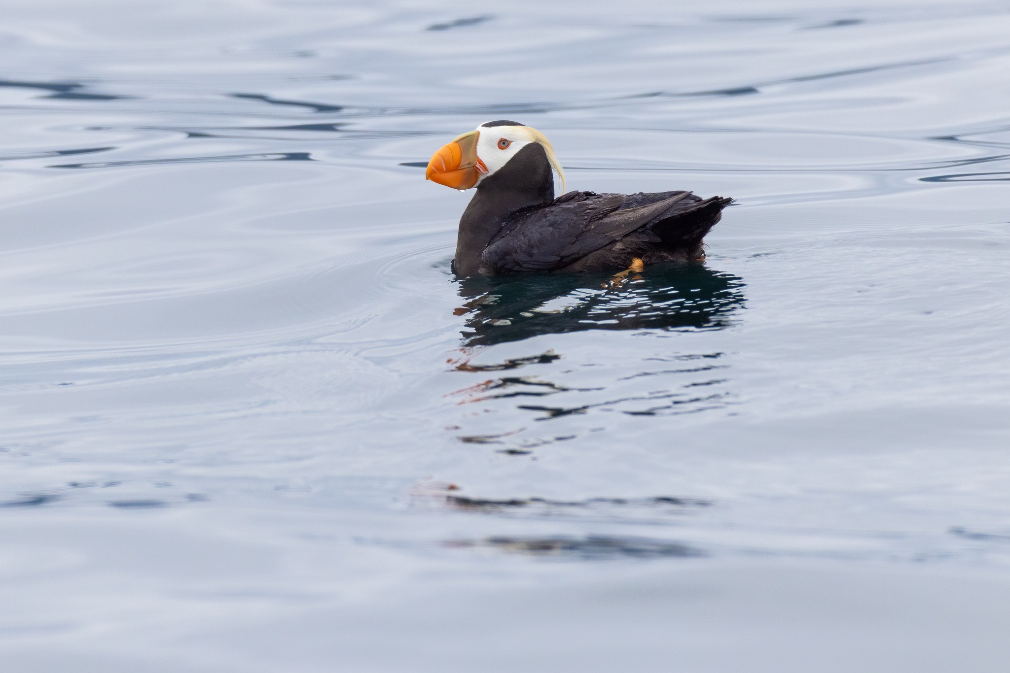
| This is a mixed flock of Common Murres (Lifer!) and Horned Puffins. |
 |
| Horned Puffins on a rock. With views of wings, feet |
Puffins are funny birds. They're diving birds, which means they dive down underwater to find food. There are lots of diving bird species out, but most of them (e.g. cormorants) swim by using webbed feet. Puffins are a different type, however; they swim by flapping their wings underwater! We were able to see this first-hand in the Alaska Sea Life Center in Seward. If you are ever in Seward, be absolutely sure to swing by the Sea Life Center -- it's awesome.
 |
| Short and narrow wings of a Puffin |
Anyway, for swimming underwater with wings, I think you want shorter, thinner wings in order to minimize drag from the water. That's exactly the sort of wing that Puffins have. This makes them pretty poor fliers, however, because in air you want longer, wider wings for better lift. Watching puffins fly is sort of humorous because the flap like mad but are barely able to maintain a height of 5-6 feet off the water.
 |
| This was the closest we got to any of the Horned Puffins. They were not comfortable with our ~75-foot boat moving in on them. |
 |
We passed a rock covered in Steller Sea Lions. I'm struck how they lie all over each other, kind of the way a litter of puppies will do. |
This is a Rhinoceros Auklet (Lifer #3 for the day), a truly bizarre bird. This is one of two auklet species we saw that day. The naturalist was much more excited about the other species, but they were both cool for me.
 |
| Rhinoceros Auklets in the water. They're still weird-looking birds. |
 |
| Humpback Whale tail fluke + Glaucous-Winged Gulls floating around. |
 |

Parakeet Auklets (Lifer #5 for the day), something that really got our naturalist excited. Apparently these things are in the area for about 6-8 weeks total, long enough to mate, lay eggs, fledge their babies, then head back south. If you look at their range maps, they are only reported to breed in about 15 fairly small areas worldwide, one of them being the Northwestern Fjord region in Kenai Fjords NP.

Orcas! We saw maybe 4 different pods of Orcas on this trip, and learned a ton about Orca biology and behavior.
First up, Orcas are often called Killer Whales, but they are not in the whale family at all -- they're in the Dolphin family! They eat pretty much anything they wanted, and are one of top predators of Moose. I'm not kidding about the moose; apparently moose will wade into fairly deep water to munch on kelp, and they are helpless when the orcas attack.
In general, there are three "ecotypes" of Orca: Resident, Transient, and Offshore. The resident orcas tend to stay in one fairly small region. Transient orcas come and go, and offshore orcas live in deep-water oceans.
One of the really interesting things we learned was that resident orcas generally hunt fish, while transients generally hunt mammals (sea otters, seals, dolphins, and sometimes even whales!). These two different ecotypes have developed very different hunting strategies, different social behaviors, and even vocalizations. Recent research (conducted by researchers from the Alaska Sea Life Center!) indicates that the three ecotypes are almost certainly different species. In particular, mitochondrial DNA studies indicate that the resident and transient ecotypes have not interbred in at least 100,000 years. Super cool.
 |
 |
| I just liked the look of this spire of rock. If you look close to the waterline you can see some Steller Sea Lions hanging out on the ledges. |

 |
| This isn't Northwest Glacier, but it's close by. We sailed past the small island and got close to the glacier, then turned to the right and went farther into the little bay. |
 |
| Finally, Northwest Glacier comes into view. I had to ask the captain to stop the boat for a moment so I could shoot a longer exposure and try to capture the reflection. IMO it was worth the effort. |

One of the things that amused me was all the names the glaciologists assign to icebergs depending on their size. I suppose this is like the story from one of the Douglas Adams books where the guy has all these different names for rain. Anyway, the size of the thing the seal is on makes it a "bergy bit." Seriously

The wildlife was amazing on the trip out to Columbia glacier was amazing, but many of the people on the boat were here to see Columbia glacier, and especially to witness a calving event. Witnessing this is both jaw dropping amazing, and also heart rendingly sad, when you realize how the glaciers are dying due to climate change.

These are orcas in the foreground. And that little sandbar in the background, covered with gulls? That's the terminal moraine from Northwest Glacier. It's mostly submerged but peeks out around low tide.
The story here is that to reach the glacier itself, the boat had to travel through a cut in the terminal moraine. It's pretty narrow and not very deep, but the boat captains all know where it is. And apparently the orcas do too! The orcas here are a pod of the Transient Orca's, also sometimes called Biggs's Orca's. And apparently there was only one pod of transient orcas that knew where to find the cut...until last year, when a completely different pod learned about the cut. The theory is that a male had been living with one pod that knew about the cut, then returned to his birth pod and took the knowledge with him. How far will knowledge of the passage through this terminal moraine spread? No one knows
 |
| We pulled up to this rock and Zach the Naturalist said "Hey, there are some Thick-Billed Murres up there. We had seen two of the Murres already, so were quite interested in the new one. We, of course, didn't see them. After several minutes of patient explanation about what to look for and *where in the view* to find the new species, we finally were able to locate them and see the difference for ourselves. |

Look at the two black & white birds in the center of the frame. The one to the left of center is a Common Murre, a species of which we had seen hundreds over the past week. The one to the its right is a Thick-Billed Murre, which is the Lifer species that we saw on this trip. Notice how it's little squatter/rounder than the Common, and has a white stripe along the bottom of the top section of the bill? If you compare the two, you'll also see that the bill shape is a little different between them. The Thick-Billed has a thicker, stubbier bill, while the common is thinner and pointier.

More birds! These are Pelagic Cormorants. I There are lots of different Cormorant species in the USA. We get two in Austin on a regular basis (double-crested, neotropic). I used to work for a company based in San Diego, and did some birding in the SD area after work on various trips to the company HQ. In San Diego they see three species (Brandt's, double-crested, pelagic), so I have seen Pelagic Cormorants before. The difference is that California is the non-breeding part of the range for Pelagic Cormorants, so I had never seen them in breeding plumage before the Alaska trip. The non-breeding plumage is basically just black, so seeing them all colored up was kind of cool.
 |
| I mentioned that Alaska also has Red-Faced Cormorants. Here is one! This is the only individual of this species that we saw, and it was busy preening so I wasn't able to get a clear profile view of the face. Oh well -- at least this is enough to positively ID the bird! |
 |
| Quick look at a mating pair of Black Oystercatchers. Zach the naturalist told us that these birds make for life, to such extremes that if one of them dies, the other will not take a new mate! |

The Steller Sea Lion is an enormous animal, with the males weighing as much as 2500 pounds! The females are much smaller, averaging 1/4 as much. Zach the Naturalist said that the closest relatives to sea lions are bears, whose skeletons are almost identical other than the feet. Sea lions, unlike seals, can actually walk although it’s more of a waddling shuffle than the gait of any land animal.
In this photo you can see the large male in the center of the frame. He’s probably enforcing his will on the other, younger, males in the photo. You can see the females studiously ignoring the squabble.
One other fun fact: all sea lions are more or less the same color; the difference in appearance is whether they’re wet or not.

This is an absolutely terrible photo of one of the most exciting sights from the Major Marine tour. I was equipped for bids (telephoto lens) when a Fin Whale surfaced a hundred yards or so in front of the boat. That means I was using a microscope to photograph a butterfly. Oops.

When this one surfaced, I was absolutely stunned at how long it was in sight. That is, it poked up, blew a spout, and started gently descending. We watched whale flesh slide by for maybe 10-15 seconds. I had a hard time understanding just how much whale went past us.
It was time to return. It was actually past time to return. It felt like the guides were having a great a time as we were. Which, considering the start of their morning, is testimony to how phenomenal the crew really was. We were headed back in, when the Naturalist cried, "Wait! There!" He was soooo excited. We got to see a salmon shark. No photos, just incredible memories.
What a day! We got to see Finn Whales, Humpback Whales and Orcas. We got to see a Mountain Goat, lots of Sea otters, Stella Sea Lions and Harbor Seals. And we got to see 9 lifer birds (Common Murre, Thick-billed Murre, Pigeon Guillemot, Kittlitz's Murrelet, Parakeet Auklet, Horned Puffin, Rhinoceros Auklet, and Red-necked Phalarope.
We arrived back at port around 6pm, grabbed dinner at a place in Seward and then headed home to our yurt.
-------------------------------------------------------------
Friday, July 5 Drive Time: 0 hrs Overnight: Sourdough Sue's Yurts
Major Marine Northwestern Fjord Cruise ($289pp) 8:30am 8.5 hours. Smaller boat with 60 passengers. Goes farther into Kenai Fjords NP.


Alaska Sea Life Center
We then went to the Alaska Sea Life Center, which was entertaining but super packed due to the holiday weekend. We spent some time looking at the exhibits, but due to the large crowds, we didn't stay as long as we might have. The guys really enjoyed the displays.
We then stopped by Exit Glacier, but a bus had parked in a way that shut down access to the glacier, so we instead went birding in some marshes by the air port (didn’t see much), and then had a relaxing evening in our yurt.
-------------------------------------------------------------
Saturday, July 6 Drive Time: 2 hrs 30 min Overnight: Flight home
Spend morning in Seward doing anything missed, then drive 2 hours to Potter marsh, possibly stopping at Alyseka Tram. Explore Anchorage
Potter Marsh for birds and wildlife
Stop at Crow Creek Gold Mine on the way to Anchorage. Adds 30 total minutes to trip to Anchorage. Self guided tour of gold mine, pan for gold for $25 per person
See Bore Tide at 6pm from Anchorage
Duck fart shot from Peanut farm
Chocolate waterfall from Alaska Wild berry products

We got another somewhat early start in the morning, unsure of what traffic would be like. We headed north back to Anchorage and stopped at Potter Marsh outside Anchorage for some birding. The weather was pretty cold and rainy, and we didn’t see much, so we headed into town.
Moose's Tooth
We had tried to eat at Moose’s Tooth when we first arrived, but it had a long wait, so we ate a late lunch here. It was good, but I am not so sure about the “second-best gastropub in the US”. We all really enjoyed our meal, though.
Earthquake Park
We then explored Earthquake Park, which was actually very interesting. I kinda wish we had visited this before we started our trip, as it would have really brought home some of the things we learned during our road trip, about the change in the land after the earthquake.
We had hopes of seeing the big bore tide scheduled that evening for 6pm. We arrived early to Beluga Point, but never did see the Bore Tide (which we were told to expect to not see it). We did not see any belugas, either. But hey, you gotta try!
We then headed to the airport, returned our car, and got ready to go home.
A truly incredible adventure. There were lots of things we didn’t get to do, and lots of places we didn’t get to, but very little that we did, that I would have wanted to miss. Alaska is just too big and amazing to see in one trip!
And, while not part of our Alaska trip, after we arrived back in Austin from our red-eye flight, we then popped in the car to go pick-up our two new puppies!

Short Itinerary
Day 1: Arrive Anchorage late pick up rental, head to hotel and crash
Day 2: Depart Anchorage by 9am. Drive to Telkeetna for Flightseeing tour check in by 12:45. Arrive late to Denali, set up camp.
Day 3: Morning options: Denali Visitor center, Sled dog demo at 9:20am, 10 am ranger-led hike, Horseshoe Lake trail hike. Afternoon: 2pm East Fork Transit bus - bring light dinner, jump out somewhere pretty, catch next bus back
Day 4: Morning and early afternoon options: 7am East For Transit tour (if available), Discovery hike, Mount Healy overlook hike (4 hours), anything missed on previous day. Late afternoon: head to K’esurgi Ken Campground
Day 5: Morning options: Stop at Sock Eye burn for woodpeckers, Hatcher Pass and Independence Mine, Afternoon options: More Hatcher Pass, set up camp at Finger Lake campground, Idiatarod HQ, Musk Ox Farm or Reindeer Farm, as time permits
Day 6: Morning options: Anything missed previous day or Lion's Head trail hike (2 hour hike). Afternoon: Matanuska Glacier at 2 pm Overnight: Tolsona Campground
Day 7: Morning options: Fishing or Mud Volcano hike at Tolsona, Wrangell-St Elias Visitor Center. Afternoon: 1pm Copper Canyon Discovery tour. Evening: Late night camp setup at Blueberry Lake Campground
Day 8: Day options: Thompson Pass, Valdez Glacier Lake, Crooked Creek Info Center, Homestead Trail Hike, Solomon Gulch Hatchery, Valdez Museum
Day 9: Columbia Glacier Kayak tour (10 hours)
Day 10: Morning: Fishing with Valdez Water Taxi Afternoon: Anything not already done in Valdez
Day 11: Morning: Ferry trip - pack up camp at 4am to catch Tuesday ferry (!!). Afternoon: Check in to Anchor Inn, Whittier Historic Walking Tour
Day 12: Morning Options: Portage Pass hike, Begich, Boggs Visitor Center, Beluga pointe, other stops, Afternoon options: Check in to Air B&B. Exit Glacier Hike, Tosina Creek Trail, Alaska Sea Life Center, Evening: Independence Day Fireworks at 11pm (!!)
Day 13: All Day options Options: Harding Ice Field Trek, July 4th celebrations, Alaska Sea Life Center or Tosina Creek Trail
Day 14: 8.5 hour Major Marine Glacier tour
Day 15: Head back to Anchorage for red eye home
No comments:
Post a Comment